
.png)

Gulkana River Salmon Escapement Sonar Pilot Study
Every summer, thousands of Chinook and sockeye salmon migrate up the Gulkana River to reach their spawning grounds. Understanding how many fish successfully escape the fishery and return to spawn—known as escapement—is essential for sustainable fisheries management.
Led by the Alaska Department of Fish and Game (ADF&G), this pilot study evaluated the feasibility of using Adaptive Resolution Imaging Sonar (ARIS) technology to estimate salmon passage in the lower Gulkana River. AITRC assisted with site selection, setup, and permitting coordination with Gulkana Village and Ahtna, Inc. The study will help determine whether sonar can provide accurate, non-invasive fish counts while expanding long-term monitoring capacity within the watershed.


Funded by the Alaska Sustainable Salmon Fund in partnership with Alaska Department of Fish and Game
How does sonar work?
Unlike traditional counting methods, sonar uses high-frequency sound waves to produce video-like imagery of fish moving through the river. This allows fish to be counted day and night, regardless of water clarity, while minimizing disturbance to migrating salmon.
However, the success of sonar depends heavily on the shape of the river channel. The river bottom must provide a clear viewing area so fish cannot pass unseen beneath or behind underwater features.
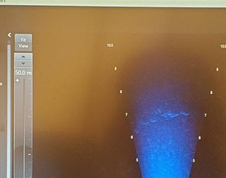
Sonar uses sound waves to detect fish moving through the river. A sonar unit sends pulses of sound through the water. When those sound waves encounter an object, such as a fish, part of the sound is reflected back to the sonar. The system measures these returning echoes and converts them into detailed videos or echograms that researchers can view on a computer. As salmon swim through the sonar beam, researchers can detect, identify, and measure for lengthindividual fish moving upstream.
Unlike a true camera, sonar does not rely on light or clear water. This makes it especially useful in Alaska's rivers, where deep, fast-moving, or turbid water can make it difficult to visually count migrating salmon. For the Gulkana River pilot study, two ARIS units were positioned, one on each bank, facing the middle of the river channel. By monitoring fish as they pass through the sonar beams, researchers can estimate fish passage and run timing with a high degree of certainty, providing valuable information on run-timing and abundance to be used for management actions.

Why this location?
The location of the proposed sonar station is an important part of this study.
Currently, ADF&G estimates Gulkana River escapement using a human counting tower located above the West Fork of the Gulkana River. Because that station is farther upstream, it does not capture the entire salmon return entering the Gulkana River system.
The pilot sonar site is located farther downstream, near the confluence with the Copper River and well below the West Fork.
Monitoring salmon at this location could allow the project to estimate passage for the entire salmon return entering the Gulkana system.


Moving monitoring farther downstream could also provide information sooner.
Because salmon would pass the proposed sonar site earlier in their migration than the existing counting station, the project could potentially provide daily passage estimates weeks earlier. Earlier information about the number of salmon entering the Gulkana River could provide useful data for responsive, in-season fisheries management.
Earlier Information for In-Season Management.


Before sonar equipment can be installed, researchers need to understand the shape of the river channel, known as its bathymetry.
Bathymetric surveys were conducted downstream of the Richardson Highway Bridge to identify locations that may be suitable for sonar. Researchers examine characteristics such as channel depth and the shape of the river bottom because sonar needs a clear view across the area where fish are migrating.
A smooth, well-defined river bottom allows the sonar beam to fully image the river channel. Large rocks, steep drop-offs, or other obstructions can block the sonar signal, creating hidden areas where fish cannot be detected. These blind spots can result in undercounting fish if site conditions are not carefully evaluated before deployment. Selecting a site with suitable bathymetry is therefore essential for producing accurate fish passage estimates.
Finding the Right Sonar Site.
What are we hopeful to learn?
The six-week pilot study will help determine whether ARIS sonar can be used to accurately and efficiently estimate Chinook and sockeye salmon passage in the lower Gulkana River, including under water conditions where visual counting may be difficult or impossible.
If the approach proves successful, this work could help establish a stronger foundation for future salmon monitoring in the Gulkana River by providing information about total salmon passage, daily run timing, and escapement earlier in the migration.

Building Future Monitoring Capacity.
This pilot study represents an important step toward expanding fisheries monitoring in the Gulkana River. If successful, a permanent sonar station could provide continuous annual estimates of salmon escapement, improving fisheries management while supporting Tribal stewardship and long-term conservation of one of the Copper River Basin's most important salmon-producing rivers.
Through collaboration between AITRC and ADF&G, this project combines modern fisheries technology with long-term monitoring efforts to improve our understanding of salmon populations in the Ahtna Territory.
Project Leads: Dan Gorze | Questions on this project?