
.png)
Lake Fish Biomonitoring: Protecting Subsistence, Food Security & Ecosystem Health
AITRC is studying fish from lakes across the Ahtna Territory to better understand how contaminants and naturally occurring elements, including mercury, lead, arsenic, and PFAS, accumulate in aquatic food webs. By analyzing fish tissues across multiple lakes and species, this project helps establish baseline conditions, identify potential environmental concerns, and better understand what these findings may mean for fish, wildlife, and people who rely on these important subsistence resources.


Funded by the U.S. Environmental Protection Agency (EPA) through Philanthropy Northwest
Understanding how contaminants move through aquatic food webs and what they may mean for fish, wildlife, and subsistence users.
Fish are an important part of both aquatic ecosystems and subsistence food systems throughout the Ahtna Territory. AITRC is studying fish from lakes across the region to better understand how naturally occurring elements and environmental contaminants enter aquatic systems, accumulate in fish, and potentially move through the food web.
By measuring substances such as mercury, lead, arsenic, and PFAS in fish tissues, this project can help establish baseline conditions, identify differences among lakes and species, and detect changes over time. Ultimately, this research helps connect water and environmental conditions to fish health, wildlife exposure, and the people who rely on these resources.
Essential and Non-Essential Elements.
Elements occur naturally throughout the environment and move through soil, water, plants, and animals.
Essential Elements.
Essential elements are needed in small amounts for normal biological functions. These include elements such as copper, iron, manganese, and zinc. However, even essential elements may become harmful when concentrations become too high.
Non-Essential Elements.
Non-essential elements have no known biological role and may be harmful even at relatively low concentrations. Examples include cadmium and lead.
Over time, some elements can accumulate within an animal's tissues, a process known as bioaccumulation. Studying those concentrations can provide information about environmental exposure, nutrition, and wildlife health.
What Is Bioaccumulation?
Bioaccumulation happens when a substance enters an organism faster than it can be eliminated, causing concentrations to build up in its tissues over time.
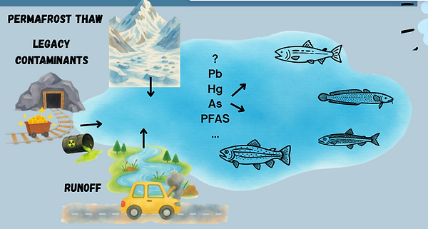
In lakes, elements and contaminants can enter the water through a variety of pathways. Some occur naturally in the surrounding geology, while others may be introduced or redistributed through runoff, atmospheric deposition, human activities, or changing environmental conditions. Once these substances enter an aquatic ecosystem, they can become available to plants and animals and begin moving through the food web.
Environment → Water → Aquatic organisms → Small fish → Larger fish
Studying fish tissue gives us a way to investigate what fish have been exposed to over time rather than looking only at conditions in the water on a single day.


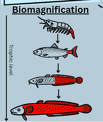
Although the terms sound similar, they describe two different processes.
Bioaccumulation is the buildup of a substance within an individual organism over time.
Biomagnification occurs across the food web. When predators repeatedly consume prey containing a contaminant, concentrations of some substances can become greater at higher trophic levels.
For example, a contaminant may occur at a very low concentration in the environment, accumulate in small aquatic organisms, move into small fish that eat those organisms, and eventually reach higher concentrations in large predatory fish.
This is one reason examining multiple fish species and sizes is valuable. It can help us understand not only whether a substance is present, but how it may be moving through the lake ecosystem.
Bioaccumulation vs. Biomagnification?
What Are We Looking For?
AITRC is investigating a range of substances that may accumulate in aquatic environments and fish tissues.
Mercury (Hg)
Mercury can occur naturally in the environment and can also be influenced by human activities. In aquatic environments, certain forms of mercury can enter food webs and biomagnify, meaning larger and longer-lived predatory fish may accumulate greater concentrations over time.
Lead (Pb)
Lead is a non-essential element that can enter the environment from both historical and current sources. Examining lead concentrations helps researchers evaluate whether fish are being exposed and whether concentrations differ among locations.
Arsenic (As)
Arsenic occurs naturally in soils, rocks, and water and can enter aquatic ecosystems through natural processes. Measuring arsenic in fish helps establish local concentrations and provides information about how it is distributed among lakes and species.
PFAS
Per- and polyfluoroalkyl substances, commonly called PFAS, are a large group of human-made chemicals that are highly persistent in the environment. Some PFAS can accumulate in aquatic organisms, making fish an important component of environmental monitoring.
Lakes are connected to the landscapes around them. What happens on the land can influence the chemistry of the water and, eventually, the organisms living within it.
Environmental changes can affect the movement and availability of elements and contaminants through processes such as runoff, erosion, atmospheric deposition, changing water conditions, and the movement of chemicals already present in soils and sediments.
Once a substance enters a lake, whether it becomes available to fish depends on many factors, including water chemistry, food-web structure, fish species, diet, age, and position in the food web.
That means two lakes located in the same region—or even two fish living in the same lake—may not necessarily show the same concentrations.
How Do Contaminants Get Into a Lake?
The project looks beyond simply asking, “Is a contaminant present?”
Instead, AITRC is interested in understanding the larger pathway:
-
Environmental conditions influence chemical inputs to aquatic systems.
-
Elements and contaminants can enter or move within lakes as environmental conditions change.
-
-
Substances become available within the lake ecosystem.
-
Once present, some can be taken up by organisms.
-
-
Concentrations may increase within individual organisms.
-
This is bioaccumulation.
-
-
Some contaminants may increase across trophic levels.
-
Predators consume contaminated prey, potentially resulting in biomagnification.
-
-
Fish tissues provide a record of exposure.
-
Analyzing tissues allows us to compare exposure among species, lakes, and potentially years.
-
-
Results can inform future research and decision-making.
-
Long-term monitoring can identify changes and help provide information relevant to ecosystem health and subsistence resources.
-

Although the terms sound similar, they describe two different processes.
Bioaccumulation is the buildup of a substance within an individual organism over time.
Biomagnification occurs across the food web. When predators repeatedly consume prey containing a contaminant, concentrations of some substances can become greater at higher trophic levels.
For example, a contaminant may occur at a very low concentration in the environment, accumulate in small aquatic organisms, move into small fish that eat those organisms, and eventually reach higher concentrations in large predatory fish.
This is one reason examining multiple fish species and sizes is valuable. It can help us understand not only whether a substance is present, but how it may be moving through the lake ecosystem.
Lakes of Interest?
AITRC is studying a variety of freshwater fish species that are important to subsistence harvest and aquatic ecosystems throughout the Ahtna Territory. Species of interest include burbot, lake trout, Arctic grayling, humpback and round whitefish, rainbow trout/steelhead, Dolly Varden, and several salmon species.
The project aims to collect approximately 10 fish from each of two to three target species per lake, where possible. By sampling fish with different diets and positions in the food web, researchers can compare contaminant concentrations and better understand how substances accumulate and move through aquatic ecosystems.
These species include both smaller fish that feed primarily on invertebrates and larger predatory fish that consume other fish. Comparing their tissue concentrations helps researchers investigate bioaccumulation and potential biomagnification while providing information relevant to subsistence food security.
What Fish Are We Looking For?

Methods used.

Baited Hoop Traps
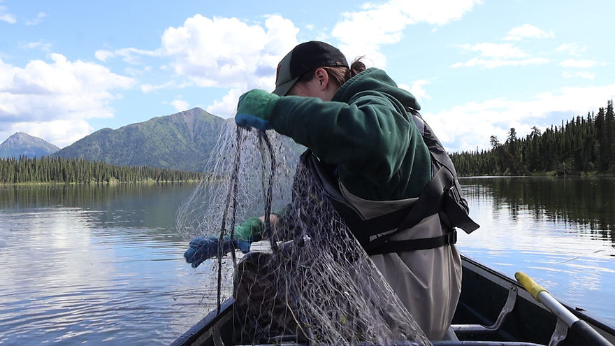
Hoop traps are cylindrical, netted traps with funnel-shaped openings that allow fish to swim inside while making it difficult for them to find their way back out. The traps are baited to attract fish, set on the lake bottom, and later retrieved by staff. Because fish remain alive inside the trap until it is checked, hoop traps are especially useful when fish need to be identified and measured before determining which individuals will be collected for sampling.


Project Leads: Kelsey Stanbro | Questions on this project?